Not everyone needs a full-fledged car navigator with a countless set of often unclaimed functions. Sometimes there is a need for the simplest and easiest voice navigation application that will simply allow a hiker or traveler to find their way to their starting point.
So, we bring to your attention an excellent application “I’m going home”, which simply must live in the smartphones of mushroom pickers, hunters, scouts, hikers and other people who often find themselves in forests or on unfamiliar rough terrain. Now you can be sure that you will never get lost.
You must understand that the main task of this navigator is to lead you to your starting point. The program is very simple, but copes with its purpose with a bang. There are no maps, compasses, or sensors. The main opportunity is to use voice prompts to correct the direction of movement of the smartphone owner to the starting point. At the same time, you must understand that the application will not guide you along the return route, but along the shortest path to your home (starting point). Therefore, if you see a quagmire or a cliff in front of you when returning, go around them. The program will not replace your eyes, but after going around an obstacle, it will again continue to lead you to the house in a straight line, adjusting the route. If necessary, you can use Google Maps - the application is compatible with them.
Price: Free
OPERATING PROCEDURE
The algorithm for working with the navigator looks something like this:
1. Launch the application
2. Turn on GPS
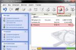
3. We are waiting to receive the coordinates of your current location (displayed in a gray window) - these will be the coordinates for returning
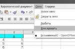
4. Press the menu button on the phone and from the menu that appears, select “Record”
5. Next, you will be asked to write down the coordinates as a word: for example, “Camp”. After that, click “Record and select.”
6. That’s it, now that the coordinates of the conditional “home” are entered into the smartphone, you can turn off the program or even the smartphone itself. Then, when you need to find the way to “home,” simply launch the navigator and press the green “Let’s go home” button.
It’s clear that you can enter a lot of such conditional “houses” into the program and then simply choose the one you need from them.

As you can see, “I’m going home” is an ideal navigator in its simplicity and necessary capabilities for mushroom pickers, berry pickers, hunters and hikers, which will not let you get lost. The program works on devices with Android version 2.1 and higher and with support for GPS navigation.
Installing the program is simple. Download the installation file with the .apk extension, upload it to your smartphone and start installing the application.
This application offers a huge reference book with detailed description hundreds of different mushrooms and high-quality photos. Which of them can be eaten, where and when they grow, what they can be confused with - here are the answers to all the questions.
The main feature of the application is the ability to recognize a mushroom through a smartphone camera. For this purpose they are used neural networks, which at the output offer several most likely answer options. The function is experimental and cannot be trusted 100%, but the detection accuracy is very high.
2. Mushroom Picker's Guide
This directory app features a more modern interface and easy navigation. From the menu on the left you can quickly navigate to the edible and inedible sections. All of them are supplemented with several photos, a description and an indication of the season when they can be collected.
No less useful will be advice and articles that provide answers to many questions about poisonous mushrooms and possible poisoning. There is also a visual showing the seasonality of all mushrooms from the directory. With its help you can find out when is the best time to go to the forest.
3. Mushrooms
The simplest reference book, not overloaded with unnecessary information. There are only three sections in it: edible mushrooms, inedible and useful articles. For each mushroom, a description is available indicating other names, classification, nutritional qualities and other useful information.
The app has a favorites feature that makes it easier to access previously marked mushrooms, as well as notes. The latter allow you to leave your comment on any mushroom. Among other things, it is worth noting the function of changing the font and end-to-end search across all content.
4. Ecoguide - mushrooms and guide
An extensive encyclopedia for iOS containing descriptions of more than 300 types of mushrooms. A guide that takes into account 24 morphological and ecological characteristics will help in recognizing them. There are also quite a few supporting articles and even various dishes. You can test your own knowledge using a special quiz.
All application content is available even without an Internet connection, however free version Photos of mushrooms are shown only in black and white. To access color photographs you need to pay.
5. Mushrooms: a large encyclopedia
Another detailed guide with the function of recognizing mushrooms through a smartphone camera. As with any other similar application, no one guarantees absolute accuracy, but you can significantly narrow your search with its help.
Another interesting feature is the function of creating photo notes with saving coordinates. It allows you to create your own map of mushroom places for each year. It is also possible to save any articles from the database in the favorites list, so that the main thing always remains at hand.
Mandatory!
The problem of turning a smartphone into a hiking GPS navigator has been solved. The main navigator is now a smartphone; in terms of functionality and ease of use, it leaves far behind all existing special hiking devices. GPS navigators. And in terms of reliability, sensitivity and time battery life he matched them.
I must say, it was not me who solved the problem, but the manufacturers of smartphones, batteries and software. I only selected worthy candidates and tested them in practice. I won’t make any secrets, I’ll be happy to share detailed recipes, use them and continue experimenting.
First about the software.
There are dozens of programs that turn a smartphone into a navigator. The choice according to my requirements left only one program: Locus Map (Locus Map). It is written only for Android, so the choice of smartphones has narrowed significantly. There is a free, slightly trimmed version of Locus Free, the full version of Locus PRO costs $8 one time, I advise you to install it right away, because when upgrading from Free to Pro, you will have to do all the settings again, and there are a lot of them.
So, the main advantages of Locus, because of which it turned out to be out of competition:
- Availability of high-quality free offline vector maps of the whole world based on OSM (Open Street Maps). Here's a link to one of them. There are terabytes of regularly updated maps.
- The program understands raster maps, which are easy to make yourself from scanned paper maps. For example, using the Mapc2Mapc program. The beloved General Staff will easily take root here. Here is a gift for you: a map of Crimea and the Lycian Way in Turkey that I made. You will find instructions for using the Mapc2Mapc program just below.
- Convenient recording of track and waypoints. You can draw a track manually and place waypoints anywhere, not just at your current location.
- Conveniently upload your tracks and points. Both of them can be placed in an unlimited number of folders, enabled/disabled by folders, or individually.
- There is no limit on the number of points, tracks and points in tracks.
- The ability to disable auto-locking of the display (the display will still turn off to save energy) and assign functions to the volume keys, such as zooming. In practice, this means that the navigator can be controlled without pressing the screen. This is also true when the screen is wet and does not respond correctly to gestures.
- It is possible to locate directories with maps on an SD card.
- Absolutely everything is customizable: the type and size of the cursor, its position (in the center or on ¼ of the screen), the color and width of the tracks, the size of the point icons, options for displaying the names of the points (permanently, open by tap or when approaching)…
- Unlimitedly customizable trip computers: amount of data, location, font (size, transparency and color) - in any combination.
- Fine-tuning the recording of track points by time, distance and accuracy. This allows you to record only the points of real movements, and not wandering around and jumping hundreds of meters with poor communication with satellites.
- Configuring the use of the internal compass and barometer: filtering depth, on and off limits.
- Setting the GPS receiver to turn off to save power (always on, always off, only on when in use)
- Customize all buttons on the top and two side panels, auto-hide.
- Running the application as a service, which eliminates failures when other applications are running simultaneously (calls, photos...). For example, for me, track recording pauses during calls, if not turned on as a service.
- The program is developing and constantly improving, new convenient functions appear, bugs are fixed when working on new smartphones and versions of Android.
Is it really more than a list? I only wrote down what was interesting to me. The program's capabilities are simply incredible; the developers are trying to create the most universal GPS-based application. Due to the huge number of settings, it is not easy to understand them. I will describe how to make the most necessary things for the hike.
This is what my program window looks like with a vector map of Crimea. The difference from the default one is only in the buttons at the top, on the side and in the trip computer.
Setting up Locus.
1. Select all default directories- in the phone memory, Not on external map SD. This is done in the settings - miscellaneous. Directories for vector maps locus/mapsVector and raster maps locus/maps can also be placed on an external SD card by specifying this in the program settings.
2. Download a map of the area where you are so that you have something to work with.
First, copy vector maps (in .map format) to locus/mapsVector, and raster maps to locus/maps. If you took a vector map from the link above, then they come with their own styles, which Necessarily you need to install it by going to the site with maps from your smartphone https://www.openandromaps.org/en/legend/elevate-mountain-hike-theme. In a collumn " Quick install in Android" Click Locus. Then you need to enable themes. First, activate the vector map. Then drag the bookmark at the bottom left. there you select “external” and there will be “Elevate” and “Elements”. They are exactly the same, but the first is by default designed for wild areas, the second for the city. The only difference is in the checkboxes that include different elements on the map. The theme needs to be installed once, suitable for all cards.
The map can be downloaded directly to the smart phone. The maps are multilingual, the language can be switched for each map separately, click the three dots in the catalog with maps to the right of the map name.
There is a big drawback to maps from the openandromaps.org resource. The problem is with street names in populated areas. There are either none, or they are displayed only on a couple of scales. But in terms of detail in the wilderness, these maps have no equal.
It happens that the program sees newly downloaded maps after rebooting the smartphone.
3. Now some important settings. The rest can be left as default.
If you don’t want to deal with long disputes, you can just restore my settings from backup copy. Download the settings file, copy it to the phone in the Locus/Backup folder (do not unpack it, just as downloaded, with the .zip extension), and then in the program menu select “Additional functions” - Backup manager - Restore. Please note that in these settings, map folders are configured in the phone memory by default. If you want, change to an external SD card.
My trip computer and themes for maps from the openandromaps.org resource are already built into the settings file.
If you still want to figure it out yourself (due to constant updating of the application, the settings may be in other sections and renamed):
Editing the top and right sidebar buttons.
Entering the editor - long tap on any element of the panel - panel settings. We set the number of buttons on the top panel to 5, the right panel to 2 and change the elements (remove unnecessary ones and add new functions): GPS, Data, Maps, Track Recording, Trip Computer, New Point, New Route. Move elements by clicking on the icon. "GPS" is the satellite visibility icon. Yellow - no signal, green - there is a signal. “Data” is a directory of your tracks and points. “Maps”—entrance to the catalog with maps. “Record track” opens an additional track recording panel (it can be adjusted, I recommend placing it at the bottom). “Trip computer” turns on/off the selected computer, and with a long tap you select the computer. You can draw whatever you want through settings/additional functions/route editor. I didn’t like any of the ready-made ones - the symbols were too large and covered half the screen. I made simple little black numbers at the top of the card, on the left. It shows speed, altitude, distance traveled. “New Point” records the center of the screen as a new point, asks for the name and destination folder. “New Route” allows you to draw a route manually. I use this function as a distance meter.
The first five buttons will be on the top panel, the rest on the side panel.
The sixth, leftmost element of the top panel changes differently: just click and select from several options. I advise you to choose GPS here. Will show the accuracy and number of visible satellites. If the accuracy is displayed at, say, 50m, then the navigator can fool you at 300m; you should not take such readings seriously.
Controls/Screen:
- “Lock auto-rotate” - check “all screens” and “portrait mode” (this will disable auto-rotate display)
- “Disable screen lock” - check the “Disable all locks” checkbox (the screen will still turn off when not in use, but it will not need to be unlocked with gestures)
Controls/Map Screen
- hardware buttons: zoom control
Controls/panels and buttons
- left panel buttons - map style switch - check the box. This is a switch of those very topics. Different themes for different purposes
- It is better not to enable auto-hiding of the top, bottom and function bars, they do not interfere if the screen is more than 4.5 inches
Recording tracks:
- pedestrian profile: 20m/10s/35m
- view of the track recording panel - bottom panel
GPS and sensors:
- launch at application startup - always
- Disable when inactive - I advise you to uncheck the box.
- compass-auto switching, 2km/h
- use true path angle: yes
Miscellaneous:
- exit confirmation: yes
- Locus as a service: yes
Points and tracks:
- track line style: I advise you to choose purple color so as not to blend in with any symbols on the map, track width: 4px
Compass calibration
Locus has a function that allows you to use the built-in compass. But it definitely needs to be calibrated from time to time. For some reason, the compass setting often gets lost.
You can do this like this: open the application Google Maps. Wait until the location is determined and a blue circle appears in the center, marking where you are now. Briefly tap on it, and in the window that opens, at the bottom left, click “calibrate compass.” If the accuracy is written: “high,” then you don’t need to do anything. And if the accuracy is average or low, then turn the phone as shown in the figure until you see a message that the compass is configured.
Instructions for converting raster maps into the Locus.sqlitedb format using the Mapc2Mapc program.
Download the Mapc2Mapc program and install it. In the free version, the functionality is the same, but the map will be littered with red crosses. If this is critical for you, the license costs a one-time fee of $20. Or look for the broken version. I've only seen older versions, they have a lot of bugs and worse functionality.
The program has the ability to link a card: File/load image for calibration. But I haven’t figured out this option and am linking maps in oziexplorer. How the binding is done is a separate topic, read specialized sites and forums.
Open the desired map: File/Load calibrated map. Sometimes the program finds it difficult to select a projection. For example, for Pulkovo1942 (our favorite General Staff) you need to choose from the list, this is Russia, Georgia or Asia.
Then File/Write map for mobile device, select Locus/Rmaps/Galileo .sqlitedb from the list. You can leave Zoom and all the checkboxes as default. Click OK. Now attention! A page will open where the map is divided into squares and you can disable any. If you click OK here, the number of squares increases 4 times so that you can select more accurately. If you do not need to throw out individual pieces of the card (or you have already thrown it away), check the “No more selections” checkbox and click OK. The conversion will begin. Depending on the size of the card and the performance of the computer, it can take a lot of time, up to several hours. Look for the converted map next to the original one.
About smartphones and increasing their reliability.
Once Locus is selected, Iphone and others automatically disappear, leaving only Android. It would be nice to use a special protected smartphone. They are not only protected from damage and water, but can also work normally in temperatures down to -20. True, they are so hefty that you don’t want to carry them around in everyday life. And if you don’t have the means to buy a separate device for a hike, you can get by with a regular smartphone with water protection. Super impact protection is useless. You need to put the smart in silicone, stick it on protective glass and tie the device with a cord to your backpack or belt. The cord is ordinary, 35-40 cm long, so that the phone does not reach the ground and does not interfere with putting it to your ear. If your phone doesn't have an eyelet for a lanyard, you can attach it to the silicone case.
This is how I carry mine in my backpack pocket.

Experience has shown that minimum requirements such: 4 nuclear processor 1.5 GHz, 2 GB RAM, 5″ screen. It is vital that the screen can be operated normally in the rain, that is, when there are drops of water on it and your fingers are wet. For example, Samsung S7-S10 has such screens. I have already tried Samsung S5, S7 edge, S9+ and am very pleased.
Autonomy of the smartphone.
Conventional devices can withstand 1.5 hiking days under the following conditions: constant track recording, moderate use of the screen, constantly in touch, 10 minutes of calls, 5 MB of Internet (mail, weather forecast). If you turn off the connection, it lasts for 2 days. Not much. Removable batteries are a thing of the past, now the only option is to charge. The solar battery charging option is not suitable for active hiking. Attaching it to a backpack is inconvenient and ineffective. Can be used normally solar charging only on vacation.
Therefore, there is only one way out: charging from a power bank with lithium-ion batteries. I have already tried a dozen of them, of different designs. You need to choose according to the optimal combination of main parameters: capacity, weight, price, reliability and convenience. With weight and price, everything is simple and clear. But with the most important thing - capacity, manufacturers are messing up. First: absolutely everyone indicates the capacity of the internal battery for a voltage of 3.7V. But it comes out of the power bank 5V. Second: no one indicates the efficiency of the converter from 3.7 to 5V. And it ranges from 70 to 88%. Typical figure is 80%. So it turns out that it is written 10000mAh, but in reality it is 5400-6400mAh. This power bank will charge a 3600mAh smartphone battery from 5 to 100% 1.5 times.
Manufacturers also mess with the charge and discharge current. Of course, to a lesser extent. The higher the charge current, the faster the power bank charges. And the greater the current supplied (per discharge), the faster the phone will charge. Take power banks with fast charging capabilities, this is very important when you only have a short opportunity to connect to an outlet while on a hike.
From the point of view of reliability and convenience, I consider it optimal to use power banks with a “written” capacity of around 10000mAh. One large one is certainly more economical in price and weight. But power banks are often lost, forgotten and broken. Therefore, it is safer to take several smaller pieces.
A solar panel on a power bank is a useless weight. It takes 2 weeks for her to charge it!
The built-in flashlight is a dangerous thing because it likes to turn on accidentally and wastes its charge in vain.
I measure the capacity of power banks with a USB tester. And it’s even better not to compare capacity, but Watt hours. Then we avoid the need to take into account the voltage, which changes during the measurement process and produces an incorrect result.
Here are some tested options for comparison to get an idea of how different they are.
Globex 11500mAh: weight 240 g (plastic body), actual capacity 6000mah/30Wh. Charges with a current of 1A, outputs up to 1.5A. Full charge time 10 hours.
Drobak power roverII 10000mAh: weight 280 g (steel case), actual capacity 5400mAh/27Wh. It charges and produces 0.85A. Full charge time 12 hours.
Xiaomi 10000mAh: weight 210g (aluminum body), actual capacity 6400mAh/32Wh. Charges 2.2A, outputs 1.8A. Full charge time 5.5 hours.
Xiaomi 2 10000mAh (with fast charging): weight 222g (aluminum body), actual capacity 6520mAh/32.6Wh. Charges 2.2A/5V, 1.5A/9-12V, outputs 2A/5V, 1.5A/9-12V. Full charge time is 3-5.5 hours.
If you consider that Xiaomi is also not expensive, then they win in all respects! Here is a photo of the hero:

One BUT: the market is flooded with fakes of terrible quality. Look for an original item in trusted stores with a good reputation, and under no circumstances look at one-page sites with a discount of many%. By the way, do not buy anything on such sites! The real price per 10,000 is 15-20 dollars.
The rest of the tested power banks were collapsible, using standard 18650 batteries. Here is the best of them, TOMO:


The charger separately weighs 108 grams, each battery weighs 46 grams. All together weighs 292 grams. It charges and outputs 1.8A. In terms of money, it’s a little more expensive than the previous ones. TOMO has 4 independent charge/discharge channels, one for each battery. There is a charge indicator separately for each battery. And it even shows the strength of the recoil current. It is not necessary to insert all 4 batteries, it will work from one. Of course, the key here is the quality of the batteries. And I took the best ones - industrial Panasonic NCR 18650B with a real capacity of 3300-3400 mAh. This is the discharge capacity, measured with a special charger. That is, the total was 13400mAh. When discharged, 7200 mAh comes out of the TOMO. Obviously, the efficiency of the converter is only 72%. Very bad. Another important nuance: when turned off, the discharge current is 0.34 mA for each battery. This means that 8% of the charge will go to waste in a week. So you need to remove the batteries if it is temporarily lying around idle.
I also tested similar charges, but with one charge/discharge channel, with batteries connected in parallel. The results are similar to TOMO, but the execution is poor and the quality is low. During the hike, I didn’t dare rely on such things; they would let me down at any moment. One plus is that when the device is turned off, there is no discharge at all.
What are the advantages of charging on 18650 batteries: You can take one charger for 2-4 batteries, and take as many batteries as you need! Yes, at least 10. It will be cheaper and easier.
The main drawback was discovered on the very first trip. Often poor contact with batteries. You have to wipe them and rotate them. You think it's charging, but it's not really charging or it's weak. Such a serious drawback offsets the advantages in price and weight. In addition, they all have low efficiency. So I recommend non-separable power banks.
Another use for power banks is charging batteries for cameras and video cameras. If their charging only works from 220V, it doesn’t matter: on aliexpress you will find USB 5V chargers for all types of batteries.
Please note: per month lithium ion batteries self-discharge by 10%. Therefore, be sure to recharge them before going on a trip.
This program will be very useful for mushroom pickers, hunters and fishermen, as well as for those who are afraid of getting lost while hiking. Precise instructions voiced in a pleasant voice will add a pleasant feeling when using this program.
Brief essence of the game
The user must get from one place to another, and the task of the “I'm going home” program is to simplify this task for him as much as possible. Many users believe that there are many such programs, but they are completely mistaken.

Nowadays there are a lot of different navigators, but they will only guide the user along paved roads. If you go mushroom picking, they will be of little use. A compass can also be an excellent assistant in such cases, but they are not entirely convenient to use.

The mushroom picker has to take out a compass, highlight it with his phone, check it, and put everything back in his pocket. But if he goes off course, the road may turn out to be much longer.

Game Features
It is worth noting that the “I’m going home” program will be very useful when going for a walk in the forest. A person needs to mark a point on the edge of the forest, after which his return home will be commanded by a program that will lead him back to the marked place.

When mushroom pickers have found a beautiful clearing and want to return here next weekend, “I’m going home” will do them a huge service. This is especially true when mushroom pickers are in this area for the first time. To return here again, you need to mark the coordinates of the clearing in the program.
In reviews of navigators, namely in descriptions of application functions, the emphasis is most often placed on opportunities for motorists and for public transport. However, there are many people who use a navigator when walking. Don't forget about tourists, athletes, mushroom pickers, hunters and fishermen.
Unlike automobile routes, pedestrian routes often use not roads, but paths, sidewalks and other transportation options. Navigators from Google Play(for Android) and in the AppStore (for iOS) do not always offer optimized paths, being limited to highways.
Therefore, in the review we will focus specifically on the possibilities when building walking routes and will offer you suitable GPS navigators for mobile devices:
As you can see, the list of pedestrian navigators is small, but over time it will be expanded. Well, as always, you can download the mentioned navigators using the links under the application descriptions.
Google Maps – a walking navigator with support for offline maps
Google Maps is perhaps one of the best free navigators that fully supports the creation of walking routes. Moreover, in our latitudes it is used more often for auto navigation. separate application– Navitel, but not Google Maps.
Anyway, mobile Google app Maps is an excellent assistant for pedestrians and tourists who need to create a route and who have a smartphone. Let's note some pedestrian functions of the application:
How to create routes for pedestrians in the Google Maps application for Android (the Internet must be turned on):
- Indicate your destination on the map (by clicking on it) - the "Route" button.
- “Go” button – Icon with a picture of a person.
- My location is "Where". Instead of "Where", if necessary, set the destination point.
Google Maps application as a walking navigator (routing)
Google Maps will select the optimal walking route, taking into account the terrain, to follow. If there are several options, you can accordingly choose the one that is more suitable for pedestrian travel. Additionally, the distance, time to travel, in steps and with turns will be indicated.
The developers of the Android application note: the walking routes are in the testing stage (there may be inaccuracies and errors). However, when traveling on foot, this is not as fatal for the navigator as when driving quickly in a car, when the smartphone must respond quickly.
A nice bonus for users mobile version(Android/iOS) – The Google Maps app also works offline. This is a useful and often indispensable function for all kinds of hiking and hiking.
You can download a map and travel to different countries without worrying about an Internet connection. At the same time, it will not be possible to build a route without the Internet; you will have to navigate only by coordinates - that is, by a marker that is synchronized by GPS.
Summary. Google Maps is good as a pedestrian and tourist navigator around the world, but without the Internet the functionality will be limited - it will not be possible to plot the optimal route automatically.
You can download this pedestrian navigator from the link:
Yandex Navigator - navigator for walking routes in Russia and the CIS countries
In 2016, Yandex Navigator for Android and other platforms acquired many additional functions and, accordingly, has become more adapted for pedestrians. Now the Yandex GPS application confidently builds routes - however, walking navigation is only available in Russia, Belarus, Ukraine and Kazakhstan.
Let's touch on the main functions of Yandex Navigator, useful in the context of the article:
- Creating routes for pedestrians with time and distance calculations
- Additional construction of alternative routes (auto, public transport) and comparison with the selected (active) route of movement
- The maximum distance for creating a route is 50 km, which is more than enough, although this may not be enough for cycling.
- Building a walking route between two houses on a smartphone
To build pedestrian routes, Yandex Navigator uses a grid of paths, paths, sidewalks - so the resulting navigation differs from highways. As developers from Yandex say, compiling such maps of pedestrian movements is quite difficult, and to finalize the maps, volunteers are used, current users of the navigator who participate in the creation of the so-called. people's map.
Like Google Maps, the Yandex Navigator application cannot plot walking routes without online access, while you can view maps and track your position without the Internet without any problems.
Summary. To summarize, we note that Yandex Navigator will be useful for pedestrians and tourists when used in the near abroad and neighboring countries. You can download this GPS app for iPhone, Android and Windows Phone.
Maps.me – pedestrian navigator for Android with detailed osm maps
Maps.me is another one free navigator, suitable for motorists, cyclists and, of course, pedestrians. You can use this GPS navigator for hiking, building walking routes and tourism.
I'm going home! - a simple navigator for mushroom pickers and hunters
Many people do not like the overly broad and mostly unnecessary functionality of mobile navigators. And gadgets like Garmin are not very convenient for simple tasks and cost a lot of money.
Application "I'm going home!" Great for fishermen too, as it only has the most basic features for pedestrians. That is why this navigator is very popular, although it cannot compete in its capabilities with other applications. It’s very easy to use; you don’t need to download or configure anything. The application will be useful for older people who have difficulty with coordination.
The "I'm going home" navigator works very simply. First, you need to turn on navigation on your phone and wait for communication with satellites. It is clear that it is advisable to do this in an open area, so that nothing interferes with stable synchronization with the satellite.
Possibilities:
- Saving the starting coordinates on the map - the place where you will need to return (for example, to the car).
- Saving any points with names and descriptions on the map in any form.
- Plotting a route from current coordinates to a given point
- Work in passive mode with voice-over capability
The navigator does not require money (it displays advertising for this) and works in Russian.